The July 30, 2025 Kamchatka Megathrust Earthquake and Pacific-Wide Tsunami: A Comprehensive Geoscientific and Impact Analysis
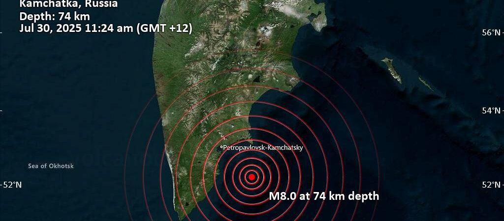
On July 30, 2025, one of the most powerful earthquakes of the 21st century struck off the coast of Russia’s Kamchatka Peninsula, unleashing a destructive tsunami that rippled across the entire Pacific Ocean. The United States Geological Survey (USGS) officially registered the event as a moment magnitude () 8.8 megathrust earthquake, making it the most powerful seismic event recorded globally since the 2011 Tōhoku earthquake in Japan and tying it with events in 1906 and 2010 as the sixth-strongest in recorded history.
The earthquake was caused by a catastrophic failure of the subduction zone interface at the Kuril-Kamchatka Trench, a hyperactive tectonic boundary where the Pacific Plate dives beneath the Okhotsk Plate. The rupture occurred at an unusually shallow depth, which maximized the displacement of the overlying water column and generated a formidable tsunami. The event was preceded by a significant
7.4 foreshock ten days prior, a harbinger of the immense stress accumulating on the fault.
The immediate impacts were most severe in Russia’s Far East. Coastal communities on the Kamchatka Peninsula and the Kuril Islands experienced severe ground shaking and were subsequently inundated by tsunami waves reaching heights of 3 to 4 meters (10 to 13 feet). This resulted in significant structural damage, particularly to port facilities, and forced widespread evacuations. The trans-Pacific tsunami triggered a basin-wide response, with warnings and evacuations ordered in Japan, the U.S. state of Hawaii, and advisories issued for the entire North American West Coast, as well as for nations in Asia, Oceania, and South America.
The long-term consequences are projected to be substantial. The USGS has estimated a high probability of economic losses exceeding $1 billion, potentially reaching into the tens of billions. The event will cause significant disruption to key regional industries, particularly fishing, and will compel a reassessment of seismic risk by the global insurance industry. The earthquake has also initiated a vigorous and prolonged aftershock sequence, with Russian geophysicists warning of the potential for shocks as large as
7.5 for a month or more, posing an ongoing threat to recovery efforts and public safety. The 2025 Kamchatka event stands as both a devastating natural disaster and a critical, real-world test of the Pacific Tsunami Warning System, providing invaluable—and sobering—lessons for all nations situated along the volatile Pacific Ring of Fire.
Section 1: Anatomy of a Megathrust Event
The July 30, 2025 Kamchatka earthquake was a textbook example of a great megathrust event, characterized by its immense energy release, shallow origin, and complex seismic sequence. A detailed examination of its physical parameters provides the essential scientific foundation for understanding its widespread and destructive effects.
1.1. Seismological Fingerprint: Magnitude, Location, and Timing
The earthquake was definitively registered by the United States Geological Survey (USGS) with a moment magnitude () of 8.8. This final figure, however, emerged after a series of rapid upward revisions from initial estimates. Seismological agencies first reported magnitudes around 8.0, a figure that was quickly adjusted to 8.7 and then finalized at 8.8 as more data became available. This progression is not an error but a reflection of the nature of great earthquakes. Initial, rapid magnitude calculations often fail to capture the full energy released by a very large and long-duration rupture. The significant upward revision indicated that seismologists were observing a rupture process far more extensive than first realized, a critical piece of information for tsunami forecasters.
The mainshock occurred on July 29, 2025, at precisely 23:24:50 Coordinated Universal Time (UTC). For the local region, this corresponded to 11:24:50 AM on July 30, 2025 (PETT, UTC+12). The epicenter, the point on the Earth’s surface directly above the earthquake’s origin, was located at latitude 52.473°N and longitude 160.396°E. This places the event in the Pacific Ocean, approximately 119 to 136 km (74 to 85 miles) east-southeast of Petropavlovsk-Kamchatsky, the administrative capital of Russia’s Kamchatka Krai.
A crucial factor in the earthquake’s destructive potential was its shallow depth. The hypocenter, or focus of the quake, was located just 20.7 km (12.9 miles) beneath the seafloor. This shallow origin is a defining characteristic of tsunamigenic earthquakes, as the vertical displacement of the seafloor is more efficiently transferred to the overlying column of water, generating a much larger initial tsunami wave than a deeper earthquake of the same magnitude.
1.2. The Rupture Process: A Violent Unzipping of the Seafloor
The earthquake was the result of shallow reverse faulting along the megathrust interface that defines the region’s subduction zone. In this process, the overriding Okhotsk Plate was violently thrust upwards and to the west as it slipped over the subducting Pacific Plate, releasing centuries of accumulated strain in a matter of minutes.
The scale of this rupture was immense. The USGS estimated that the segment of the fault that failed measured approximately 390 km (240 miles) in length by 140 km (87 miles) in width—an area larger than the country of Switzerland. The GEOSCOPE Observatory calculated that the rupture process itself, the time it took for the fault to “unzip” along this vast area, lasted for more than 180 seconds, or three full minutes. This prolonged period of violent shaking is a hallmark of a great megathrust event and is a primary driver of both intense structural damage on land and the massive displacement of water that generates a trans-oceanic tsunami.
1.3. The Seismic Sequence: Foreshocks and Aftershocks
The 8.8 mainshock was not an isolated event but the climax of a dynamic seismic sequence. On July 20, 2025, just ten days before the main event, a powerful 7.4 earthquake struck the region. This foreshock, located about 60 km (37 miles) southwest of the mainshock’s eventual epicenter, was a major earthquake in its own right and served as a critical physical warning. It represented the failure of a smaller, highly stressed patch on the fault, which, rather than relieving the overall strain, transferred its stress load to the larger, more strongly locked segment of the megathrust. This stress transfer likely pushed the main segment past its breaking point, triggering the catastrophic
8.8 rupture.
Immediately following the mainshock, a vigorous and terrifying swarm of aftershocks began. Within the first hour, a cascade of powerful tremors struck, including an 7.0 event just 24 minutes later, followed by an 6.9 and an 6.3. This relentless series of aftershocks compounded the damage to already weakened structures and created a state of continuous peril for residents and emergency responders. The Kamchatka branch of the Geophysical Service of the Russian Academy of Sciences issued a stark warning that significant aftershocks, potentially reaching magnitudes as high as 7.5, could be expected to continue for at least a month, representing a long-term and unpredictable hazard.
| Table 1: Key Seismological Parameters of the 2025 Kamchatka Earthquake | ||
| Parameter | Value | |
| UTC Date & Time | 29 July 2025, 23:24:50 | |
| Local Date & Time | 30 July 2025, 11:24:50 (PETT) | |
| Magnitude () | 8.8 | |
| Epicenter Coordinates | 52.473°N 160.396°E | |
| Depth | 20.7 km (12.9 mi) | |
| Type of Faulting | Megathrust (Shallow Reverse) | |
| Max. MMI | VIII (Severe) | |
| Rupture Dimensions | ~390 km x 140 km | |
| Rupture Duration | >180 seconds | |
| Strongest Foreshock | 7.4 (20 July 2025) | |
| Strongest Aftershock | 7.0 (30 July 2025) | |
Section 2: The Tectonic Engine: The Kuril-Kamchatka Subduction Zone
The 2025 Kamchatka earthquake was not a random act of nature but the violent culmination of immense geological forces operating over millions of years. The event was born in the Kuril-Kamchatka Trench, one of the most dynamic and hazardous tectonic settings on Earth, placing it within a long and violent history of seismic activity.
2.1. A Plate Boundary in Motion
The earthquake’s origin lies at the Kuril-Kamchatka Trench, a major convergent plate boundary where the dense oceanic Pacific Plate dives, or subducts, beneath the lighter continental Okhotsk Plate. The Okhotsk Plate is a microplate that is often considered part of the larger North American Plate in this region. This relentless process of subduction, which has been ongoing since the Cretaceous period, is the engine that created the Kuril Island chain and the active volcanoes that define the Kamchatka Peninsula.
The plates are converging at a rate of approximately 77 to 86 millimeters per year (about 3 to 3.4 inches), roughly the same speed at which human fingernails grow. Over decades and centuries, this steady motion builds up an enormous amount of stress and elastic strain along the fault interface where the plates are locked together. When this accumulated stress finally overcomes the friction holding the plates in place, the fault ruptures in a great megathrust earthquake, releasing the stored energy in the form of seismic waves. The Kuril-Kamchatka Arc is one of the most seismically prolific regions in the world, having hosted 133 large earthquakes (magnitude 7.0 or greater) and 12 great earthquakes (magnitude 8.0 or greater) in the period since 1900 alone.
2.2. A Ghost from the Past: Comparison with the 1952 Kamchatka Earthquake
The 2025 earthquake immediately drew comparisons to the region’s most infamous historical event: the catastrophic magnitude 9.0 Severo-Kurilsk earthquake of November 4, 1952. The 2025 event was the strongest to strike the Kamchatka Peninsula in the 73 years since that disaster.
The geological connection between the two events is striking. The epicenter of the 2025 M 8.8 earthquake was located just 45 km (28 miles) southeast of the 1952 event’s epicenter, indicating that the two ruptures occurred on adjacent or partially overlapping segments of the same megathrust fault system. The 1952 event was even larger, rupturing a colossal 600 to 700 km (370 to 430 mile) long section of the subduction zone. It generated a devastating Pacific-wide tsunami that completely destroyed the town of Severo-Kurilsk in the Kuril Islands. The tsunami’s power was such that its waves reached Hawaii with heights of up to 9.1 meters (30 feet), causing over $1 million in damage in 1952 U.S. dollars, though remarkably, no fatalities were recorded there.
The proximity of these two great earthquakes, separated by only 73 years, provides a powerful case study in how subduction zones behave. It challenges simplistic models of “seismic gaps,” which suggest that segments of a fault that have recently ruptured are unlikely to fail again soon. The 1952 event released an enormous amount of strain, but the 2025 earthquake demonstrates that either some segments did not fully rupture in 1952, or that 73 years of steady plate convergence was sufficient to reload the fault system with enough strain to produce another earthquake of nearly the same magnitude. This has profound implications for long-term hazard assessment in other major subduction zones, suggesting that the recurrence interval for great earthquakes in a given region can be well within a single human lifetime.
| Table 2: Comparison of the 2025 and 1952 Kamchatka Megathrust Events | |||
| Metric | 2025 Event | 1952 Event | |
| Date | 30 July 2025 | 4 November 1952 | |
| Magnitude () | 8.8 | 9.0 | |
| Epicenter Location | 52.473°N 160.396°E | ~45 km NW of 2025 epicenter | |
| Rupture Length | ~390 km | ~600-700 km | |
| Tsunami Height (Kamchatka/Kurils) | 3-4 meters | Destructive, town destroyed | |
| Tsunami Height (Hawaii) | Warning issued, ~6 ft peak-to-trough at Midway | Up to 9.1 meters (30 ft) | |
| Reported Fatalities (Russia) | Several injured, no immediate fatalities confirmed | Significant, town destroyed | |
Section 3: The Immediate Epicenter: Impact on Russia’s Far East
While the tsunami’s reach was global, the earthquake’s most violent effects were concentrated at its source, inflicting severe damage and terror upon the sparsely populated but strategically important regions of Russia’s Far East.
3.1. Violent Ground Shaking and Structural Damage
In the city of Petropavlovsk-Kamchatsky and surrounding towns, the ground shook violently for up to three minutes. The intensity of shaking in the city was rated as VIII (Severe) on the Modified Mercalli Intensity (MMI) scale. This level of shaking is capable of causing considerable damage in ordinary buildings and heavy damage in poorly built structures.
Eyewitness accounts and official reports painted a picture of chaos and damage. Residents in Petropavlovsk-Kamchatsky fled into the streets, many without shoes or proper outerwear, as their apartment buildings swayed violently, balconies shook, and cars were rocked in the streets. Inside homes, cabinets toppled and mirrors shattered. Key infrastructure sustained direct hits. The ceiling of a terminal at Elizovo Airport, which serves Petropavlovsk-Kamchatsky, collapsed, injuring a woman. A kindergarten building was also significantly damaged, though fortunately it was unoccupied at the time of the quake. The shaking also caused widespread power outages and failures in mobile phone service, severely hampering initial communication and emergency response efforts.
3.2. The Tsunami’s First Strike: Inundation and Destruction
The shallow offshore nature of the earthquake meant that a powerful local tsunami was generated almost instantaneously. Within minutes, waves measuring between 3 and 4 meters (10 to 13 feet) high slammed into the eastern coast of the Kamchatka Peninsula and the nearby Kuril Islands.
The port town of Severo-Kurilsk, located on Paramushir Island in the Kuril chain and home to approximately 2,000 people, bore the brunt of the tsunami’s force. The Russian Ministry for Emergency Situations confirmed that the town’s port was inundated. A fish processing plant, a cornerstone of the local economy, was flooded and its structures were swept away by the waves. Live media reports described a sequence of waves, with a third powerful surge tearing ships from their moorings and carrying them out to sea. Videos from the area showed coastal buildings submerged and vast areas of land under water.
3.3. Human Toll and Emergency Response
Despite the immense energy released by the earthquake and the destructive power of the tsunami, initial casualty reports were remarkably low. Russian health officials stated that while several people sought medical help for injuries sustained during the panic—some from falls while running outside, one from jumping out of a window—no serious injuries or fatalities were immediately confirmed.
This relatively low human toll can be attributed to two key factors. First is the region’s geography and sparse population. The most intensely affected land areas are remote, and the main population center of Petropavlovsk-Kamchatsky, with about 180,000 residents, was over 100 km from the epicenter. A Russian geophysicist noted that due to the specific characteristics of the rupture, the shaking intensity in the city was not as high as might have been expected from an earthquake of this magnitude. The primary destructive force was the tsunami, which directly impacted smaller coastal towns.
The second factor was a swift emergency response. Russian authorities issued immediate evacuation orders for vulnerable coastal communities like Severo-Kurilsk, urging residents to move to higher ground. A state of emergency was declared on the tsunami-hit islands, allowing for the full mobilization of resources to manage the crisis.
Section 4: A Trans-Pacific Threat: The Tsunami’s Journey and Arrival
Generated by the violent upheaval of the seafloor off Kamchatka, the tsunami radiated outwards from the epicenter at the speed of a jet airplane, transforming a regional disaster into a Pacific-wide threat. The event triggered a complex, multi-national response, testing the capabilities of the international warning system developed over decades to prevent a repeat of past tsunami tragedies.
4.1. The Pacific Tsunami Warning System in Action
Within minutes of the earthquake, the Pacific Tsunami Warning Center (PTWC) in Hawaii, working in concert with national agencies like the Japan Meteorological Agency (JMA) and the U.S. National Tsunami Warning Center, issued a series of alerts across the Pacific basin. Using seismic data to rapidly assess the earthquake’s magnitude, location, and tsunamigenic potential, these centers disseminated warnings to dozens of countries, setting in motion a cascade of emergency procedures from Asia to the Americas.
4.2. Japan: A Nation on High Alert
Given its proximity to the epicenter and its own tragic history with tsunamis, Japan responded with utmost urgency. The JMA issued a tsunami warning for the country’s extensive Pacific coastline, initially predicting waves of up to 3 meters (10 feet). An evacuation advisory was issued to over 900,000 people residing in 133 municipalities, stretching from the northern island of Hokkaido to the southern islands of Shikoku and Kyushu. In a public address, Prime Minister Shigeru Ishiba urged citizens in the affected areas to evacuate immediately.
The first tsunami waves arrived on Japan’s shores relatively quickly but were smaller than the maximum predictions. Wave heights of 30 to 50 centimeters (1 to 1.6 feet) were observed at various locations, including Nemuro on Hokkaido and the port of Ishinomaki. Officials repeatedly broadcast warnings that a tsunami is not a single event but a series of waves, and that subsequent waves could be significantly larger. The alerts caused major disruptions to daily life, with ferry services and some local train lines suspended. All nuclear power plants along the coast reported no abnormalities, though as a precaution, workers at the still-decommissioning Fukushima Daiichi plant were evacuated to higher ground.
4.3. United States: A Multi-Front Response
The tsunami’s path across the Pacific prompted a multi-layered response across the United States.
- Hawaii: The state of Hawaii was placed under a full Tsunami Warning, the highest level of alert. The National Weather Service warned of “destructive tsunami waves” and ordered the immediate evacuation of all coastal and low-lying areas. The alert coincided with evening rush hour in Honolulu, leading to major traffic jams as residents scrambled to reach higher ground. The U.S. Coast Guard ordered all commercial vessels to evacuate harbors throughout the islands. The first waves were predicted to arrive around 7:00 PM local time. While the inundation was not as severe as in the 1952 event, data from buoys at Midway Atoll, northwest of Hawaii, measured waves of 6 feet from peak to trough, indicating a significant displacement of water had indeed crossed the ocean.
- Alaska and the West Coast: A Tsunami Warning was also issued for the remote and sparsely populated Aleutian Islands of Alaska. For the continental U.S., the entire West Coast—spanning California, Oregon, and Washington—was placed under a Tsunami Advisory. This is a lower-level alert indicating the threat of strong currents and dangerous waves that could pose a risk to people in or near the water, but not widespread inundation. Officials in Oregon predicted waves of 1 to 2 feet and urged the public to stay away from beaches, harbors, and marinas. Small waves of less than one foot were ultimately observed in Adak, Alaska.
4.4. The Global Reach: Other Pacific Nations
The threat was truly basin-wide. Canada issued a tsunami advisory for the coast of British Columbia. Warnings and advisories were also issued for a host of other nations, including China, the Philippines, Indonesia, Taiwan, and as far away as New Zealand. China’s national warning center predicted waves of up to 1 meter along its coast. The PTWC’s projections indicated that some coastlines in South America, particularly in Ecuador, could see waves of over 3 meters, with waves of 1 to 3 meters possible in Chile and Peru.
The successful detection and dissemination of warnings across this vast expanse represent a triumph of international scientific cooperation. However, the disparity between the high-level warnings and the more modest observed wave heights in many areas highlights a persistent challenge. While erring on the side of caution is non-negotiable for public safety, the significant social and economic disruption caused by mass evacuations can lead to “warning fatigue” or a “cry wolf” effect. If the public perceives that warnings are consistently overestimated, their willingness to respond to the next alert—which could be for a truly catastrophic event—may be dangerously diminished. This underscores the ongoing need for more nuanced public communication and education about the different levels of tsunami threats.
| Table 3: Pacific-Wide Tsunami Warnings and Observed Impacts | |||||
| Country/Region | Warning Level Issued | Predicted Wave Height | Observed Wave Height/Impact | Official Response | |
| Russia (Kamchatka/Kurils) | Tsunami Warning | 3-4 meters | 3-4 m waves, port inundation | Evacuations, State of Emergency | |
| Japan | Tsunami Warning | Up to 3 meters | 30-50 cm waves, transport disruption | Evacuation advisory for 900,000 | |
| USA (Hawaii) | Tsunami Warning | Destructive waves possible | ~6 ft peak-to-trough at Midway | Mandatory coastal evacuations | |
| USA (Alaska) | Tsunami Warning (Aleutians) | Not specified | <1 ft waves in Adak | Evacuations in warning zones | |
| USA (West Coast) | Tsunami Advisory | 1-2 feet | Minor waves, strong currents | Stay-off-beach advisories | |
| Canada (BC) | Tsunami Advisory | <30 cm | Not specified | Stay-off-beach advisories | |
| China | Tsunami Warning | Up to 1 meter | Not specified | Warning issued | |
| South America (Ecuador) | Tsunami Warning | Up to 3 meters | Not specified | Alert issued | |
Section 5: Projected Consequences and Long-Term Outlook
The immediate shaking and tsunami waves represent only the first chapter of the 2025 Kamchatka earthquake’s story. The event has set in motion a series of cascading consequences that will unfold over months and years, impacting the region’s economy, environment, and society, while also sending ripples through global systems of finance and risk assessment.
5.1. The Economic Fallout: Beyond Initial Damage
The direct economic costs of the earthquake are projected to be substantial. The USGS PAGER (Prompt Assessment of Global Earthquakes for Response) system issued its highest-level “RED” alert for economic losses. This classification is based on models that estimate a 41% probability of total economic losses falling between $10 billion and $100 billion USD, and a 93% probability that losses will exceed $1 billion. These figures account for the direct costs of repairing or replacing damaged buildings, ports, airports, roads, and other critical infrastructure.
Beyond these direct costs, the earthquake poses a significant threat to the regional and even global economy through the disruption of key industries. The damage to the port and the destruction of a major fish processing plant in Severo-Kurilsk represent a severe blow to the vital Russian fishing industry in the Far East. The Sea of Okhotsk and the waters around Kamchatka are among the world’s most productive fisheries. Prolonged closures of ports due to damage, debris, or the ongoing threat from aftershocks will have significant ripple effects, potentially disrupting global seafood supply chains and affecting international commodity prices.
Furthermore, this event will reverberate through the global insurance and reinsurance markets. A disaster of this magnitude serves as a critical real-world data point for the financial models that underpin the industry. Insurers will be forced to recalibrate their assessment of risk for the entire Pacific Ring of Fire. This will almost certainly lead to increased premiums and stricter conditions for earthquake and tsunami coverage in other high-risk coastal zones, such as Japan, the U.S. Pacific Northwest, and South America. In this way, an earthquake in a remote corner of Russia can indirectly raise the cost of insuring a home or business in Seattle or Santiago.
5.2. Environmental Transformation and Hazards
Great megathrust earthquakes are powerful enough to permanently reshape the physical environment. The violent upward thrust of the seafloor that generates the tsunami is often matched by a corresponding sinking, or subsidence, of the nearby coastline. While measurements from Kamchatka are not yet available, historical analogues provide a stark warning. The 1700 Cascadia earthquake, for example, caused coastal lands in what is now Oregon and Washington to sink by as much as 2 meters (6.5 feet), permanently flooding coastal forests with saltwater and creating the “ghost forests” that are still visible today. Similar long-term subsidence is a distinct possibility in Kamchatka, which would permanently alter ecosystems and increase the vulnerability of the coastline to future flooding and storm surges.
The tsunami itself causes immediate and widespread environmental damage. The powerful waves scour the seabed, destroying near-shore marine habitats like kelp forests and shellfish beds. The inundation of land results in massive saltwater intrusion into coastal freshwater aquifers, rivers, and soils, which can have long-lasting effects on local agriculture and ecosystems. The report of four whales washing ashore on the coast of Japan is an early, anecdotal indicator of the tsunami’s profoundly disruptive impact on marine life across the ocean basin. Finally, the intense and prolonged ground shaking on the steep, volcanic terrain of the Kamchatka Peninsula has significantly increased the risk of landslides, a secondary hazard that can threaten communities and block transportation routes for weeks or months after the initial event.
5.3. Geopolitical and Social Implications
For the residents of the affected regions, the danger is far from over. The official forecast from Russian scientists of strong aftershocks, potentially as large as magnitude 7.5, continuing for a month or more creates a state of chronic psychological stress and anxiety. This enduring threat complicates every aspect of the recovery, from the safety of rescue teams to the decisions of when to begin rebuilding.
On a larger scale, the earthquake serves as a powerful, real-world preview for other regions around the Pacific that are bracing for their own “Big One.” The images of destruction from Kamchatka and the data on tsunami propagation across the ocean will be studied intensely by emergency managers, engineers, and policymakers in the U.S. Pacific Northwest (the Cascadia subduction zone), Japan (the Nankai Trough), and South America. This event will provide fresh impetus and political urgency to accelerate efforts in those regions to seismically retrofit critical infrastructure, improve tsunami evacuation routes and vertical shelters, and enhance public awareness campaigns. The 2025 Kamchatka earthquake is not just a Russian disaster; it is a wake-up call for the entire Pacific Rim.
Conclusion
The July 30, 2025 Kamchatka earthquake was a historically significant geological event, a violent manifestation of the inexorable tectonic forces that shape our planet. Born from the immense strain accumulated along the Kuril-Kamchatka subduction zone, this 8.8 megathrust earthquake unleashed destruction upon Russia’s Far East and sent a tsunami across the world’s largest ocean, touching the shores of dozens of nations. Its legacy, however, is a complex and dual one.
On one hand, it is a story of destruction, loss, and ongoing hazard. The communities of the Kamchatka Peninsula and the Kuril Islands face a long and difficult road to recovery, confronted with damaged infrastructure, a disrupted economy, and the persistent threat of powerful aftershocks. The event has permanently altered the physical landscape and inflicted a deep psychological toll on its population. It stands as a stark reminder of the immense destructive power that can be unleashed from beneath the seafloor.
On the other hand, the event is also a story of scientific success and a powerful testament to the value of international cooperation. The Pacific Tsunami Warning System, a global network built from the hard-won lessons of past tragedies, performed its mission with remarkable speed and accuracy. Within minutes of the rupture, alerts were propagating across the basin, providing precious hours of warning to distant populations. The swift evacuations and emergency responses enacted in Japan, Hawaii, and elsewhere undoubtedly prevented a much greater loss of life, transforming a potential catastrophe on the scale of the 2004 Indian Ocean tsunami into a more manageable, albeit still dangerous, event.
Ultimately, the 2025 Kamchatka earthquake serves as a humbling and powerful lesson. It underscores the dynamic and often violent nature of the planet we inhabit, while simultaneously demonstrating humanity’s growing capacity to understand, anticipate, and mitigate the deadliest of these threats. The path forward requires a continued and strengthened commitment to the foundational pillars of disaster resilience: robust scientific research, resilient engineering, clear public education, and, above all, the seamless international collaboration that proved so vital in the face of the great Pacific-wide tsunami.